You are currently viewing Ophir Pass ~ A shortcut?

Ophir Pass ~ A shortcut?

We are off to the Brooklyn Road trail and then over OPHIR PASS with our Escapee friends John and Connie. 
 
The trail starts at the top of Red Mountain Pass turning east off Hwy 550 just beyond the Red Mountain Pass sign. This trail leads you past the St. Paul Lodge and along a winding ledge on the west side of the mountains. You will pass areas with mining remnants, including the Brooklyn Mine site. This is not an all-day drive. It joins Hwy 550 just north of the turnoff to Ophir Pass, 18 miles south of Ouray. 
The Brooklyn Road trail (FS825) was built in 1883. It probably looks about the same as it did then. This is not part of the Alpine Loop trail, but it is beautiful for sure.  It’s not an extremely rough or steep trail but it does help to have a  high clearance vehicle 4 wheel drive and not be afraid of passing on a one lane road.
We almost made it to the summit of this road and were stopped by a snow bank about 3 feet deep.  Lily enjoyed the romp in the snow.  We hiked to the summit and the view was amazing.
Above is the view from the summit of Brooklyn road showing a little view of the Million Dollar Highway.  The Photo Below is taken with a zoom lens of that highway.
We made the U-Turn at the snowbank and headed back down to the highway 550 and over to OPHIR PASS road.
On some of these trails you might need a Jeep with rubber tracks 🙂
The map shows our route for the day including a 5 mile bumpy side trip up to Alta Lakes.
Flowers everywhere in August!
According to Seth at Colorado 145, a place to rent a Jeep if you don’t own one; Ophir Pass Road serves as a convenient and beautiful “shortcut” for off-road enthusiasts needing to “quickly” bridge the gap between the Telluride area, the town of Silverton, and the notorious system of mountain passes known as Alpine Loop.
Seth must have had his tongue in his cheek when he used the terms Shortcut and Quickly!
We had ourselves a convoy.
The earliest version of Ophir Pass was created in 1881. It cost $15,000 to build, was a toll road, and was the main route used to transport goods between the settlements of Silverton, Telluride, Rico and Ophir. However, within 10 years of the pass being created, the railroad system had found its way over Lizard Head Pass and down to the Ophir Loop that connected Telluride and Ophir. This drastically reduced traffic over Ophir Pass and it became a wagon road that people rarely traveled.
This road/trail was first opened to Jeeps and other off-road vehicles in 1953.
The Ophir Pass Summit at 11,789 feet.
Ophir Pass Road, Forest Road #630, is considered a moderate four-wheel drive trail. It is a very rocky base, so it’s best to be in low four going down the grade.  John and Connie made it OK in their Jeep Cherokee, but they did hit bottom once along the rocky ledge.
One-half mile of this road is very narrow with a steep cliff down on one side and straight up on the other. NOT a great place to meet another vehicle. Remember downhill vehicles Yield to the ones coming up. We waited for about 10 minutes for about 10 OHVs and Jeeps to go by us before taking off the long stretch.
This one-half mile seemed to take forever as we were worried about having to share the very narrow one-lane trail with someone else. ..EEEEks
This is the road (trail) we had to continue on.
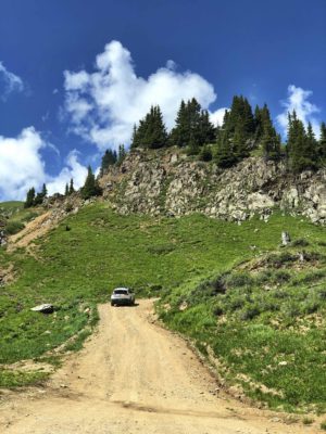
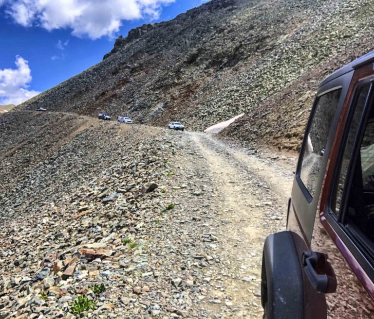
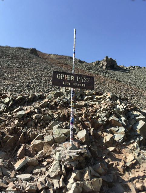
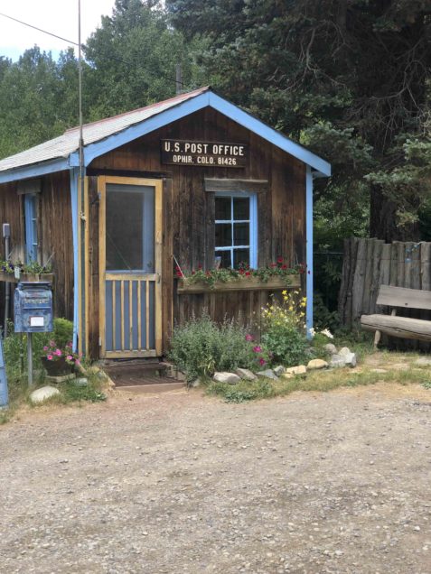
After miles of solid rock trail we came upon the Ophir Post Office, so we knew we were entering the town for sure.
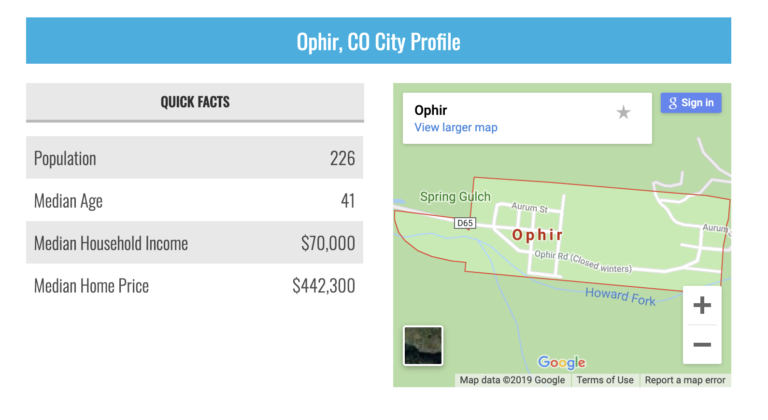
After two turns on the gravel road, a few homes and cabins, we realized, that was it… Ophir, Population 226. It happened so fast I didn’t get a picture.
So the above Quick Facts give you an idea of what Ophir is like.  No wonder in a blink we were thru the town and back in the woods.
This sign was posted as we entered and exited Ophir.
We continued on until we arrived at highway 145 and then a few miles North of here we took the Alta Lakes road for about 5 miles.
Alta Lakes
ALTA LAKES
This is one of three beautiful mountain lakes with a campground surrounding this one. Located on the backside of the Telluride Ski Resort and Palmyra Peak, Alta Lakes provides a magical alpine setting. A pack in and pack out camping area on a first-come-first-served basis. This is NOT a road for RVs or trailers. It’s a basic tent or Overhead Truck Camper campground but well worth the drive to have a picnic lunch which is what John, Connie, Mark and I did. We said our goodbyes here to Connie and John as they headed back to the Elks Lodge in Montrose.
We followed Highway 145 to the junction of 62, which took us back to Ridgway. A right turn on High550 took us back to Ouray. 
At the end of a great day, back at our basecamp in Ouray, we said our goodbyes to Connie and John. Tomorrow, the decision has been made, we will tackle the Million $$ Highway in the Motorhome on our way to DURANGO. 
NOTE: This is my first time to spend a few weeks in the mountains of Southwest Colorado. I spent all my summers growing up in the Sierra Nevada Mts in California and later in my adult life lived at Lake Tahoe for a few years. I honestly thought the California mountains were the best ever. Now that I have seen this part of Colorado,  I can’t wait to return again. 
Every time we came to the top of a pass, there would be another one even more beautiful ahead. So, if you love majestic mountains, 4 Wheeling and Quaint mountain towns you won’t be disappointed if you decide to spend some time in this area.